
Walk a Whitehall Township Street by Address
A useful Whitehall Township street directory starts with one confirmed property, not a loose name match. The county assessment card connects an address to a taxable parcel and a current owner field. Its map link places that parcel among roads and nearby boundaries. Recorded documents then test the ownership path, while dated directories or maps can test an older address. A voter status tool is for the person entering information, not for browsing an entire street. Formal voter street lists follow a separate state request and certification process.
- Enter the complete address or known PIN in the Lehigh County ORA Property Search, then retain the property address, owner fields, parcel ID, old parcel ID, subdivision, and document clues.
- Read the owner, owner-address, and property-address fields separately. The owner entry is an assessment and title lead, while the property address identifies the taxed parcel.
- Use the owner spelling and acquisition reference to search the Recorder route. Verify the legal description at every transfer rather than relying on the street name alone.
- For a voter question, use the state status service for an individual or follow the Department of State request process for an authorized public list. The online tool is not a street-browse feature.
- For an older household layer, ask the library and archive catalogs about address or reverse-directory coverage, then search dated village, directory, and map sources. Record the edition or map year with the result.
That chain keeps three ideas apart: ownership, parcel location, and evidence of a household at a particular time. It also gives a later researcher enough identifiers to repeat the search.
Whitehall Township Street Directory ORA Fields
ORA is the county’s strongest current address entry point for a Whitehall Township street directory. Its public page requires at least four search characters, disallows special characters, and presents a captcha. Choose Address, Parcel Identification (PIN), or Document ID/Instrument Number. It does not offer an owner-name or ZIP search type, and it does not promise a whole-street result. Directional abbreviations and county-listed suffixes matter when a street search fails.
| ORA control | Input or action | Required | Whitehall Township use |
|---|---|---|---|
| Enter Search Text | At least four characters, no special characters | Yes | Begin with the exact address, PIN, or document key. |
| Search Type | Address, PIN, or Document ID/Instrument Number | Yes | Select the record key already in hand. |
| Captcha | Displayed challenge | Yes | Complete it before the search runs. |
| Parcel Viewer | Map link | No | Check the parcel’s road and boundary context. |
The returned card distinguishes Owner Name, Owner Address, and Property Address. Property address, also called situs, identifies the taxable site. The owner address is the mailing field and may be elsewhere. A homestead field is tax administration data, not a list of everyone at the address.
See the captured ORA property-search controls before starting a query.
Using the published controls first reduces a bad match caused by an incomplete street form or the wrong search type.
- Parcel
- A taxable tract or property unit identified by the county. Its PIN is the strongest bridge from an address to assessment and deed records.
- Situs address
- The address of the assessed property itself. It differs from an owner mailing address when tax mail is sent elsewhere.
- Plat
- A recorded map or plan showing lots, blocks, or subdivision layout. It can help when a street number has changed.
- Criss-cross directory
- An address-to-name directory, unlike an alphabetical directory. A Whitehall-specific year run was not verified, so check the catalog before relying on one.
Note: Save the old parcel ID with the current PIN because historical deeds, tax material, and subdivision records can use a different identifier.
Map Whitehall Township Street Parcels
The Lehigh County GIS Parcel Viewer is the map half of the address workflow. Its search accepts an address, place, PIN, or partial assessment address. A selected assessment centroid leads to current detail. Parcel boundaries, roads, assessment information, municipal limits, flood zones, and other reference layers are available alongside tools for measurement, printing, filtering, querying, selecting, an attribute table, and a Buffer Report.
Start from a verified ORA card, then use the map to check road placement and the parcel outline. The Viewer is reference material, not survey-line proof. It reports assessed ownership and parcel geography, not a confirmed roster of people at nearby homes. Where a corner, alley, or subdivision line makes the street relationship unclear, use the legal description or ask the appropriate county office about a known record.
The map’s small Buffer Report defaults to 100 feet and is capped at 1,000 features. That can help inspect parcel relationships, but a carefully selected parcel is more reliable than an indiscriminate area result.
Note: Parcel boundaries define the record relationship more reliably than visual closeness, especially at corners, alleys, or irregular subdivision lines.
Trace Whitehall Township Street Deed Records
Each street address has its own parcel trail. The Lehigh County Recorder of Deeds reports 1812 to present coverage, with free index searching and paid images or copies. ORA Sales History can provide a modern document ID or an older book and page reference. Those values point to the safer Landex route than a broad name search on a busy street.
In the Landex Webstore, the name search uses county, company or last name, first name, date range, and document type. Instrument Number and Book and Page have separate tabs. Results show Matching Names, Type, Date Recorded, Municipality, Instrument Number, Pages, Price, and Cart. A result is a document lead, not proof that someone occupied the property.
The Recorder counter is at the courthouse in Allentown. Staff do not conduct open-ended research. Bring a known instrument, book and page, document type, party spelling, date range, PIN, or legal description when asking about a copy, certification, index volume, or coverage.
The Landex document-search screen illustrates the index route used after ORA supplies a document reference.
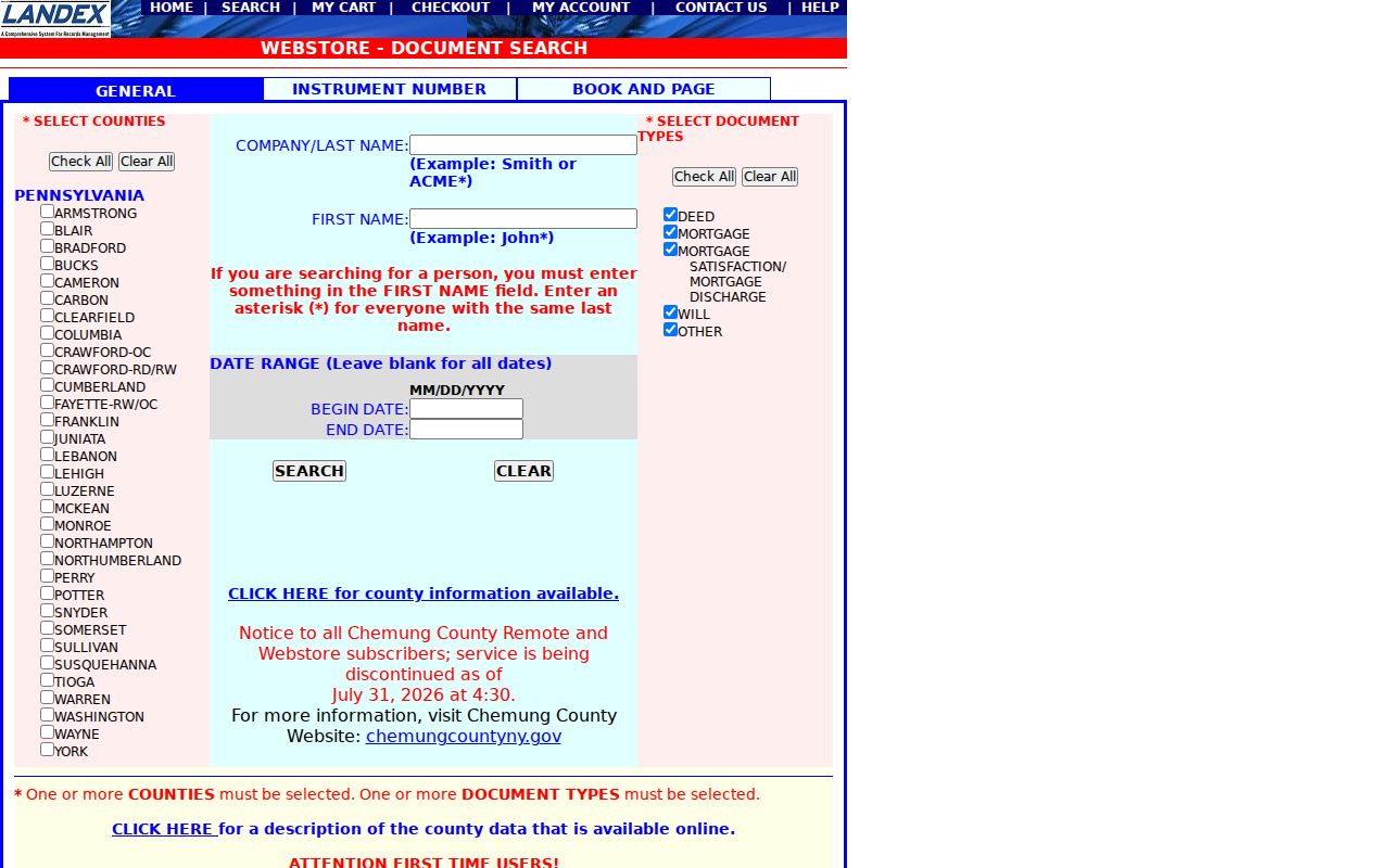
Compare the legal description, dates, and parcel clues at each link, especially where a grantor owned more than one property.
Whitehall Township Street Numbers After 1968
Ordinance 883 is a practical Whitehall Township street directory quirk. In 1968, the Township adopted master numbering as former village post offices and delivery routes were centralized. The code assigns 0001 to 1999 to Fullerton, 2000 to 2999 to West Catasauqua, 3000 to 3999 to Hokendauqua and Stiles, 4000 to 4999 to Egypt, and 5000 to 5999 to Cementon. MacArthur Road was excepted.
Older documents may therefore use a village post-office label or a shorter number that does not look like the modern address. Preserve the source form. Compare it with the old parcel ID, lot or subdivision, deed legal description, and a dated map before declaring a match. Search Cementon, Egypt, Fullerton, Hokendauqua, Mickleys, Stiles, and West Catasauqua as well as Whitehall Township.
Note: A numbered ward range is a cross-check, not a parcel-by-parcel conversion table or proof that two similar address forms are identical.
Whitehall Township Street Permit Files
For address-specific construction, inspection, code, or occupancy timing, the Township’s Planning, Zoning & Development route is separate from the county parcel and deed systems. Whitehall does not publish an address-searchable permit or complaint database. Its permit materials identify site address, tax parcel, lot, subdivision, zoning district, work type, and other keys that can narrow a request. The Township says submissions are paper, payments are cash or check, and Keycodes handles plan-review and inspection questions.
A finite records request should name the street address, parcel number when known, record class, and date span. Whitehall’s Right-to-Know form permits email, mail, fax, or in-person submission, and it asks requesters to seek records rather than ask a broad question. Code complaints have protected portions and are not a substitute for an address directory.
Use the Township permit information for the process and the Right-to-Know instructions for a targeted municipal request.
Whitehall Township Street Records by Address
These Whitehall Township street records have different keepers and limits. The address, PIN, and legal description are the useful bridges. A record that includes a name can show a property or document relationship, but it should never be silently converted into a claim that every named person lived there.
| Address record | Keeper | Street-level value | Access channel |
|---|---|---|---|
| ORA assessment card | Lehigh County Assessment | Owner, mailing address, situs, PIN, old PIN, zoning, and building clues | Public online property search |
| Parcel Viewer | Lehigh County GIS | Road, parcel geometry, assessment context, and map layers | Online viewer from ORA or GIS |
| Recorded instruments | Recorder of Deeds | Parties, recording references, and legal-description chain | Landex index, paid copies, or courthouse counter |
| Permit and occupancy material | Whitehall Planning, Zoning & Development | Work, inspection, or occupancy time markers | Counter, form, or targeted RTKL request |
| Historical maps and land records | Lehigh County Historical Society | Village, lot, map, tax, mortgage, or estate context | Collection-specific in-person research |
A parcel ID ties the assessment card to the mapped parcel and can support a deed or permit request. A street name is less durable. It may change form, cross a village label, or be reused in a new subdivision. The best Whitehall Township street directory result preserves both the modern address and its parcel or legal-description evidence.
Whitehall Township Voter Street List Route
Pennsylvania’s online registration page lets an individual check status online or by phone. It is not an open street directory. The Lehigh County Voter Registration office provides county help, while the Department of State form controls public information, street, walking, and full export lists. The form requires identification, a list choice, a county or statewide choice, and a permitted-use certification.
The Department describes a Street List as names, residential and mailing addresses, party, and active or inactive status. That access has statutory conditions under the Pennsylvania Voter Registration Act and implementing rules. The lists are dated administrative records, cannot be published on the internet, and do not reveal ballot selections. Use the state voter-status service for personal status questions and the official request form for a lawful, authorized list route.
Note: A voter-list status records administration at a point in time and cannot establish a complete or current household roster.
Whitehall Township Street History Sources
A reverse or criss-cross directory would list addresses to names, but the researched Whitehall sources did not verify a local year run. Treat it as a catalog question, not a promise. The documented route is the Lehigh County Historical Society’s Allentown city-directory run, the Allentown Public Library’s directory and census microfilm, the Whitehall Township Public Library catalog, and regional editions searched with village and street variants.
For Egypt or Cementon, LCHS holds Sanborn maps dated 1885 to 1927. A map can test the building, block, local place name, and street continuity. Pair it with a dated directory, deed, tax record, or newspaper. The historical collections themselves have their own research path on the Whitehall Township city directory page.
Whitehall Township Street Privacy Limits
A street directory cannot establish every person who lives at a property. Assessment and deed records concern taxable property and recorded parties. They can omit renters, adult children, guests, protected people, and anyone not named in the underlying record. Driver address information and utility customer information are not public property-record fallbacks. Court and vital records have their own access rules.
Pennsylvania’s Address Confidentiality Program permits eligible participants to use a substitute address in several government and court records. A public card, directory entry, or voter record must never be used to work around that protection. Redactions and omitted fields also are not an invitation to seek the information elsewhere.
Lawful use. Whitehall Township address records support personal, lawful property and family-history research. Do not use them to stalk, harass, threaten, intimidate, or expose a protected person.